
SUNDAY, 21-JUN-26 01:57
SUNDAY, 21-JUN-26 01:57

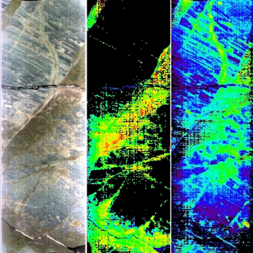
Image courtesy of Spectra-Map
"Applications of Hyperspectral Imaging in Oil and Gas"
Hyperspectral Imaging (HSI) has proven to be a quick, non-destructive analytical technique that utilises energy reflectance to identify and quantify the surface mineralogy of rock core. The imaging process can gather data over the entire surface of the core, providing mineralogy over a wide area, or alternatively take spot measurements. While HSI has been used extensively in the mining industry for many years, it has not gained widespread application in oil and gas.
The ability to highlight mineralogical variation within the reservoir not only increases the ability to understand variations in porosity and permeability but also reduces costs by using the hyperspectral images to guide sample selection. Thus, plug sample results can be linked to the hyperspectral maps and so upscaled to help build reservoir models that more accurately reflect the compositional and mechanical heterogeneities of a reservoir potentially leading to improved production of hydrocarbons.
This webinar by the Rock Imaging Special Interest Group (RISIG), the organisers of the highly regarded International Rock Imaging Summit, will demonstrate the many strengths of hyperspectral imaging and examine its use in a series of case studies presented by world-leading experts.
Members who registered for the webinar can view the presentations by logging in and clicking on the title of the talk opposite. Others may request a code to view individual presentations.


Agenda - Wednesday 16th June 2021 - all times are GMT.
Talks will be 20 minutes long followed by 10 minutes of Q&A.


BIO: Jon is a UK-trained geologist and technology developer. During the 1970s he worked on developing uses for the early Landsat series satellites for exploration and geological mapping. In the early 1980s he pioneered, with others, the first airborne hyperspectral surveys in Australia demonstrating mineralogical signatures could be identified from 10,000 feet. He was involved in the early use of the PIMA, a shoe-box sized field-portable spectrometer, and later in the TSG software package still in use today. In the mid 1990s, with colleagues Ken McCracken and Andy Green, he was awarded the Australia Prize for Science for their early work in geology image processing and utilisation.
In the early 2000s Jon transitioned from remote sensing to proximal sensing with his CSIRO team developing the suite of HyLogging core logging technologies bringing industrial-scale, objective mineralogical interpretation to the mining sector. This allowed the development of the AuScope National Virtual Core Library (NVCL) which is routinely used by all of Australia's State and Territory Geological Surveys.
Jon is a Fellow of the Academy of Technological Sciences and Engineering (FTSE) and a CSIRO Honorary Fellow.
SUMMARY: Hyperspectral sensing across the reflected (300- 2500 nm) visible, near and shortwave infrared spectrum is well understood as a rich source of characterising information for minerals and rocks that contain various oxides, hydroxyl-bearing “clays” and carbonates. This may also include spectroscopic absorptions due to organic compounds of interest to the oil and gas sector. Extending hyperspectral capabilities farther into the 6000-15000 nm (thermal) infrared, and more recently the 2500-6000 nm mid-infrared, permits even more extensive characterisation. Utilising these wavelengths for sensing carbonates better, for CH absorptions and the all-important quartz, and feldspars found in clastic sequences, plus barite, anhydrite, etc., permits getting closer to modal mineralogy of most of the main rock-forming minerals.
BIO: After completing a Ph.D in mineral spectroscopy in 1990, Gavin joined Rio Tinto’s R&D group to promote and apply infrared spectroscopy techniques for mineral exploration. In 2000, he co-founded Spectra-Map to develop the non-invasive SpecCam infrared imaging spectrometer for mineral analyses. In 2007, Spectra-Map was the first company to introduce routine IR imaging in the oil and gas exploration sector. Gavin is Technical Director at Spectra-Map, overseeing the routine application of spectroscopic methods for accurate whole rock mineral identification and quantification.
SUMMARY: The most recent advance in IR spectroscopy is in the use of real-time imaging reflectance spectrometers. These are non-contact and non-destructive, and acquire continuous mineral and hydrocarbon data in a detailed sub-mm pixel image format. Their main strength is their unique ability to accurately discriminate and quantify the clays, carbonates and sulphates, along with hydrocarbon/TOC information, from core.
Gavin will prent case histories from conventional reservoir projects from the Barents and Norwegian Seas, and from unconventional shale reservoir cores taken from the Austin Chalk and Eagle Ford Shales.
BIO: Lionel completed a Bachelor’s degree from Université de Poitiers with a specialty in mineralogy and a Master’s degree in Geosciences from Université de Poitiers and Université du Québec à Montréal. Lionel started his career as a research associate for the Institut de recherche pour le développement (IRD) in New Caledonia and as a research projects officer for CSIRO in Australia. In 2015, he joined the spectral geology division of Corescan, a global hyperspectral imaging service provider, where he specializes in the interpretation of iron ore, nickel laterite, and oil and gas hyperspectral data. Lionel is currently a senior spectral geologist and Corescan’s specialist in the development of HyLogger data interpretation (i.e., continuous VNIR-SWIR-MWIR-LWIR).
SUMMARY: Unconventional petroleum reservoirs are well suited to characterization by
hyperspectral imaging (HSI) technology. These systems typically exhibit complex textures and fine laminations and well as a high degree of variability in mineral assemblages and mineral chemistry. Hyperspectral imaging is non-destructive and a variety of sample types (e.g., cuttings, plugs, cores, hand samples, etc.) can be analyzed while preserving the samples for additional analysis. Corescan’s HSI products are RGB photography, 3D surface profiling, and interpreted HSI (i.e., mineral maps and compositional images) and downhole mineral logs derived from the HSI.
Hyperspectral imaging data from the Bakken, Three-Forks and Williston Basins in the western United States not only highlights previously identified mineralogical trends, but also reveals underestimated components. Expert-driven analysis of mineralogy and grain size calculations can provide a framework for automated mineralogical and lithological classification of these unconventional reservoirs. This can include rapid, consistent, and accurate Net to Gross (N/G) calculations in thin-bedded formations like the Three Forks. The integration of HSI datasets with well logs (resistivity and gamma), and the application of machine learning or predictive algorithms, provides further opportunities to scale mineralogical information from limited core intervals to the full well.
BIO: Friederike Koerting works for HySpex by NEO as the Geological Hyperspectral Application Specialist where she applies hyperspectral imaging to help miners mitigate risks, unlock value and save time. Norsk Elektro Optikk AS - HySpex Divison is the industry leading brand for both airborne and ground-based hyperspectral imaging and manufacturer of advanced electro optical products. Friederike wrote her doctoral thesis on superspectral copper ore detection and the implementation of hyperspectral data and instruments in the open-pit mining environment. Her experience in the VNIR-SWIR spectral range and the mapping of outcrops, mine faces and drill cores was gained through multiple field campaigns around Europe and countless hours in the hyperspectral lab analysing samples from all over the globe. She started her research as a student in 2012 and developed her skills in projects and her dissertation at the German Research Centre for Geosciences GFZ.
SUMMARY: The material distribution within a rock outcrop differs in the small scale this depends on the heterogeneity of the deposit, degree of surface weathering and different extraction horizons. Different horizons of interest and lithologies can show a high degree of variability and the subsequent processing and action steps need to be tailored to the material at hand. Common models are based on point-data (drill-cores and samples) or low-resolution spatial studies (e.g., magnetics) and can lead to misclassifications due to the interpolation and high variability of the material. Hyperspectral imaging offers a spatial detection method of the geological surface and allows for a classification of lithology-, mineral- and element-distributions. This approach enables a more efficient extraction and material-handling and a vectoring towards horizons of interest. The aim is to implement hyperspectral imaging into the mineral commodity sector and the mining environment and to offer solution for different position within the workflow. This presentation will give an overview of the different use-cases of hyperspectral data within the mining environment and presents feasibility studies and research around the development of solutions with the HySpex VNIR-SWIR systems.